Instructions for Side by Side Printing
- Print the notecards
- Fold each page in half along the solid vertical line
- Cut out the notecards by cutting along each horizontal dotted line
- Optional: Glue, tape or staple the ends of each notecard together
GIS test two, digital image processing and analysis
front 1 Remotely sensed images by themselves are not valuable. They need to be _________________. | back 1 Analyzed |
front 2 Preprocessing involves raw _____________ images with no _________________. | back 2 satellite, corrections |
front 3 What are Radiometric corrections? | back 3 Correcting for sensor irregularities, |
front 4 What are the two types of radiometric corrections? | back 4 Sensor irregularities and atmospheric irregularities |
front 5 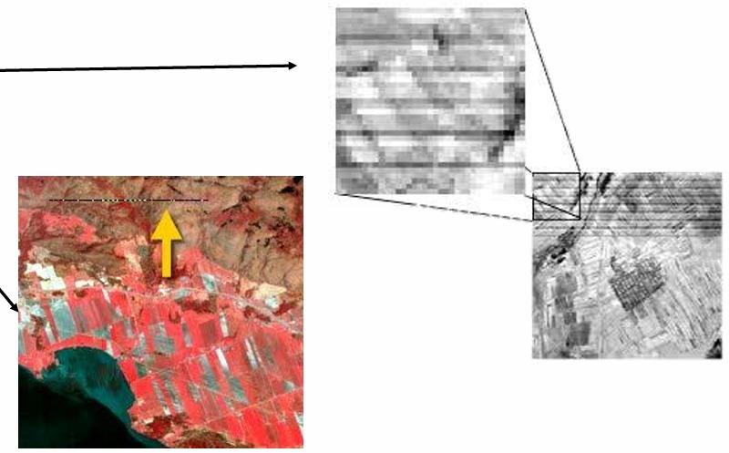 What are the two types of sensor irregularities shown here? | back 5 Stripping and dropped lines |
front 6 What are Pseudo invariant calibration sites (PICS) used for? | back 6 Calibrating sensors or accounting for variation within sensors |
front 7 For corrections to smaller images (like one taken by a drone) what manual method can be done to correct portions of the image? | back 7 Ground target collection |
front 8 What is geometric correction? | back 8 The identification of image coordinates (rows, columns) at several known points using ground control points (GCPs) AKA= telling an image where it is in the real world using reference points |
front 9 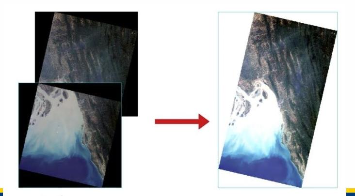 Composite images consist of at least _____ images. They ___________ the area covered, can remove_________, and reduce ____-_________ angles | back 9 2, increase, clouds, off-nadir |
front 10 __________ ________________ is used to improve the appearance of
imagery to assist with _________ | back 10 Image Enhancement, visual |
front 11 What does contrast refer to? | back 11 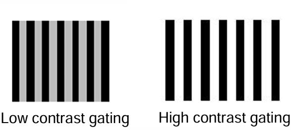 the difference in luminance or colour that makes |
front 12 Contrast enhancement does what? | back 12 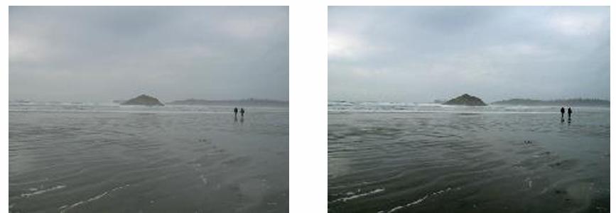 Changes the original values in the image to be displayed using the full range of available values |
front 13 What is an Image histogram? | back 13 A graphical representation of the brightness values |
front 14 What is a Linear Contrast Stretch? | back 14 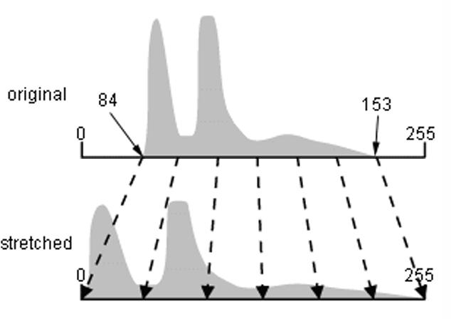 When the minimum and maximum values |
front 15 How does a percent clip work? What does it increase? | back 15 A chosen percentage of the highest an lowest values of an image are "clipped" from the histogram and everything that remains is stretched fill the gaps. Contrast is increased. |
front 16 A _____________ ______________ stretch Assigns more display values (range) to frequently occurring portions of the histogram. What data is this method the better approach for? | back 16 Histogram equalization, Better approach for data that is not normally distributed |
front 17 What is spatial frequency? What texture will areas with high spatial frequency have? Low spatial frequency? | back 17 Variation in tone that appears in an image, rough areas where changes in tone are abrupt, smooth areas with little variation in tone |
front 18 What does spatial filtering do? | back 18 Highlights or suppresses specific features in an image based on spatial frequency |
front 19  Which image has high spatial frequency? Which has low spatial frequency? | back 19 Top=high, bottom=low |
front 20 Low pass, high pass, edge detection, and directional are all types of what? | back 20 Spatial Filtering |
front 21 What is moved over pixels in an image to create a new value for the central pixel in spatial filtering? | back 21 a "window" |
front 22 Which type of spatial filtering smooths data by reducing local variation and removing noise, typically using the mean or median values of the window? What is it removing? | back 22 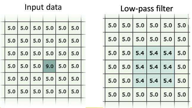 Low Pass Filtering, Removes extreme values in the data |
front 23 Which type of spatial filtering sharpens the appearance of fine detail in an image like boundaries between features? What are cells being weighted to remove? | back 23 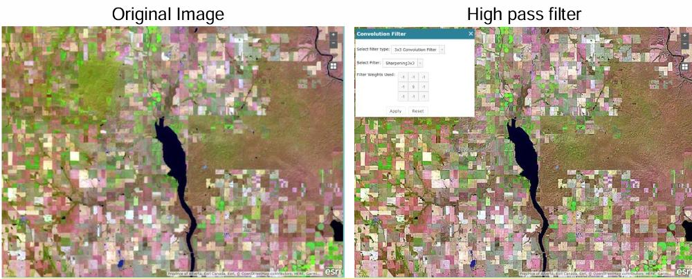 High Pass Filtering, Cells are weighted to remove low frequency variations |
front 24 What do edge detection filters highlight (give an ex)? What is this type of filter identifying? | back 24 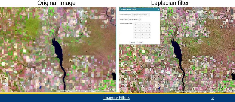 linear features such as roads or field |
front 25 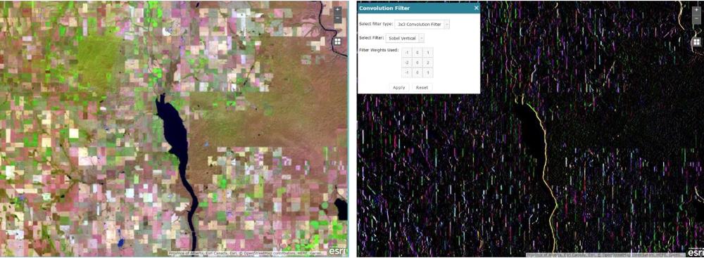 What type of spatial filter is Used to highlight features in a specific direction? | back 25 Directional filter |
front 26 What is Image Transformation? | back 26 The Generation of a new image from two or more sources which highlight a feature of interest |
front 27 Image transformation involves the combined processing of multiple ____________ _________ and applies simple ____________ operations. | back 27 spectral bands, arithmetic |
front 28 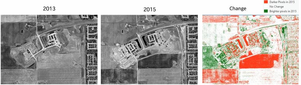 What type of image transformation is being preformed here? Hint: It's used to identify changes that occurred in the time between two images | back 28 Image subtraction |
front 29 What does spectral ratioing do? What one of the two examples given in lecture? | back 29 It enhances the variation between spectral bands. Normalized burn ratio (NBR) or Normalized vegetation index (NDVI) |
front 30 What does PCA stand for, what does it do and why? | back 30 Principal component analysis, reduces redundancy between multispectral bands via compressing them together as they are often highly correlated and contain similar information |
front 31 ______________ are the new bands that result from | back 31 Components |
front 32 Name two potential types of features that could be in Foundation mapping | back 32
|
front 33 What type of map does foundational mapping create? | back 33 A thematic map |
front 34 What does a thematic map map? | back 34 the geographic pattern of a particular subject matter (theme) in a geographic area |
front 35 Describe how you would design a remote sensing plan from start to finish. | back 35 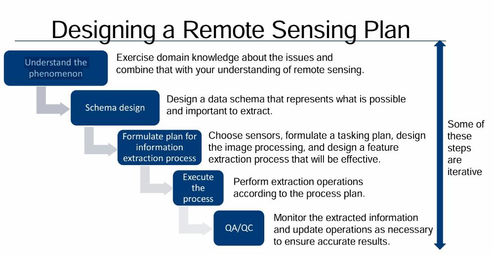 QA=quality assurance QC=quality control |
front 36 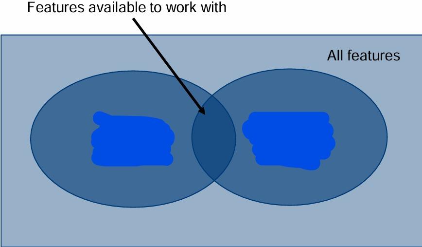 What are the labels in the Venn diagram? | back 36 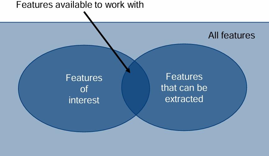 |
front 37 Why does pixel based classification work? Is it preferred to use reflectance or DN values for this technique? What type of map does this create? | back 37 Because different features have different spectral signatures and can be differentiated by those features, reflectance, a thematic map |
front 38 What are spectral classes? | back 38 Groups of pixels that have similar brightness values within their spectral channels |
front 39 What are information classes? | back 39 Categories of interest that analysts are trying to identify in the imagery (e.g., crop type, forest types, rock type…) |
front 40 What is Unsupervised Pixel-Based Classification? What are its main pros and cons? | back 40 When an algorithm sorts information into classes and labels them numerically. Pros=computer can pick up on information humans would probably miss Cons=Human needs to interpolate unlabelled classes, risk of over or under classification |
front 41 What is Supervised Pixel-Based Classification? What are its main pros and cons? | back 41 When an analyst manually creates training samples of different features to tell the computer which values mean what. The algorithm then gives back named classes in a thematic raster. Pros=There is significant control over the logic of the classification, Cons=The thematic raster may be noisy at the pixel level, accuracy dependant on training data, human bias, training data formation is time consuming |
front 42 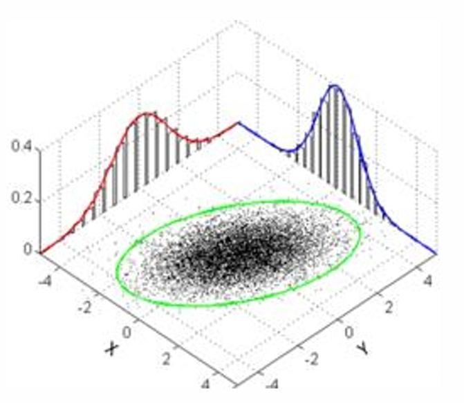 What is this? | back 42 Multivariate Distribution |
front 43 What do Object-Oriented Approaches to classification and extraction do? | back 43 Group pixels into representative polygons |
front 44 What does image segmentation do? | back 44 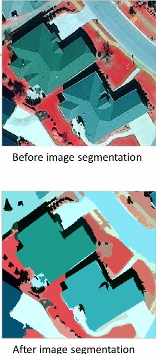 Groups pixels with similar characteristics into larger |
front 45 In Image segmentation are classes assigned to individual pixels or entire objects? | back 45 Entire objects |
front 46 What are the pros and cons of Image Object-Oriented Approaches to classification and extraction? | back 46 Pros= contextual information, reduces pixel noise cons=computationally intensive, not effective for coarse resolution, requires a model |
front 47 What is deep learning based on? What research does it originate from? | back 47 Neural networks, artificial intelligence |
front 48 What is a primary technique for applying deep learning to imagery? | back 48 convolutional neural networks (CNNs) |
front 49 What does object identification with deep learning output? | back 49 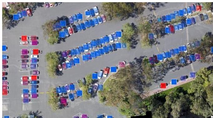 a feature layer of polygons, showing where the objects are located. |
front 50 What does pixel classification with deep learning output? | back 50 a raster with a class for each pixel |
front 51 What are some pros and cons to using deep learning? | back 51 Pros=incorporates spatial and spectral clues, can classify based on objects or pixels Cons=Needs many samples, requires an expert to teach (parameters, evaluation when teaching), over and under classification |
front 52 What is the term for The combining or merging of data from multiple sources to extract better/more information. | back 52 Data integration |
front 53 What are examples of data integration? | back 53 Radar, LiDAR |